


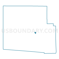
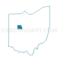
PRECINCT KENTON 1-B, Hardin County, Ohio
About
Outline

Summary
| Unique Area Identifier | 647860 |
| Name | PRECINCT KENTON 1-B |
| County | Hardin County |
| State | Ohio |
| Area (square miles) | 0.28 |
| Land Area (square miles) | 0.28 |
| Water Area (square miles) | 0.00 |
| % of Land Area | 100.00 |
| % of Water Area | 0.00 |
| Latitude of the Internal Point | 40.64199510 |
| Longtitude of the Internal Point | -83.59857500 |
Maps

Graphs
Select a template below for downloading or customizing gragh for PRECINCT KENTON 1-B, Hardin County, Ohio


Neighbors
Neighoring Voting District (by Name) Neighboring Voting District on the Map
- PRECINCT KENTON 1-A, Hardin County, OH
- PRECINCT KENTON 1-C, Hardin County, OH
- PRECINCT PLEASANT A, Hardin County, OH